

Mostantól követi felhasználót
A felhasználó követése sikertelen.
Ez a felhasználó nem engedélyezte mások számára, hogy kövessék.
Ön már követi ezt a felhasználót.
Tagsági előfizetésével csak 0 követésre van lehetősége. Itt fejlesztheti tagságát.
Nem követi a továbbiakban felhasználót
A felhasználó követésének kikapcsolása során hiba lépett fel.
Sikeresen ajánlotta felhasználót
A felhasználó ajánlása során hiba lépett fel.
Valami hiba történt. Kérjük, frissítse az oldalt és próbálja újra.
E-mail cím hitelesítése sikeres.

rawalpindi,
pakistan
Itt jelenleg ennyi az idő: 9:25 de.
Ekkor csatlakozott: július 22, 2020
0
ajánlás
Raja K.
@kalaykhan
3,4
3,4
100%
100%
rawalpindi,
pakistan
100%
Teljesített megbízások
100%
Költségvetésen belül
100%
Határidőn belül
25%
Ismételt megbízási arány
Geoinformatics Surveyor | BIM Coordinator
Keresse Raja K. felhasználót a munkájával kapcsolatban
Jelentkezzen be, hogy chaten keresztül megbeszélhessék a részleteket.
Portfólió
Portfólió
VR Panoramic 360 Architectural walkthrough
VR Panoramic 360 Architectural walkthrough
VR Panoramic 360 Architectural walkthrough

VR Panoramic 360 Architectural walkthrough
VR Panoramic 360 Architectural walkthrough


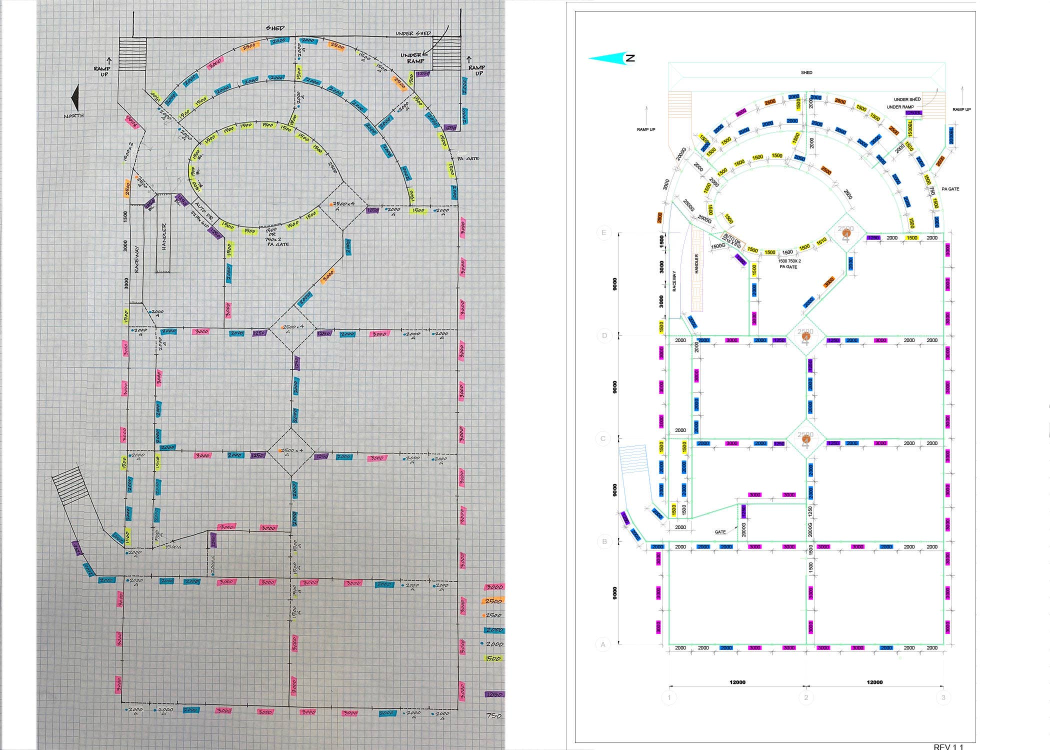
Infrastructural Bridge Modelling in Infra-works 360 BIM

Infrastructural Bridge Modelling in Infra-works 360 BIM

Freehand Sketch to CAD Drawing
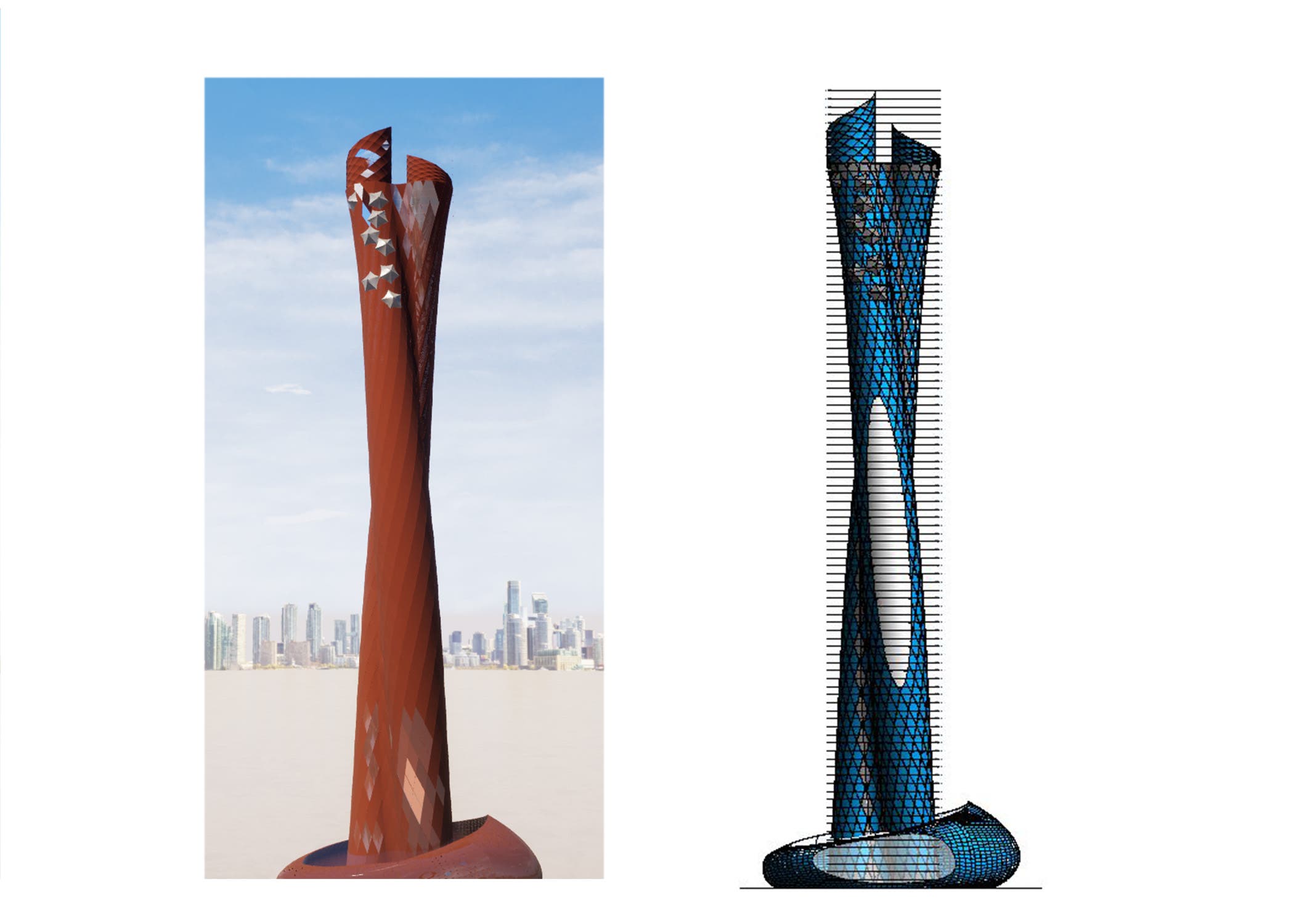

Parametric Dynamo Revit Modelling of Complex Skyscrapers

Parametric Dynamo Revit Modelling of Complex Skyscrapers

Parametric Dynamo Revit Modelling of Complex Skyscrapers
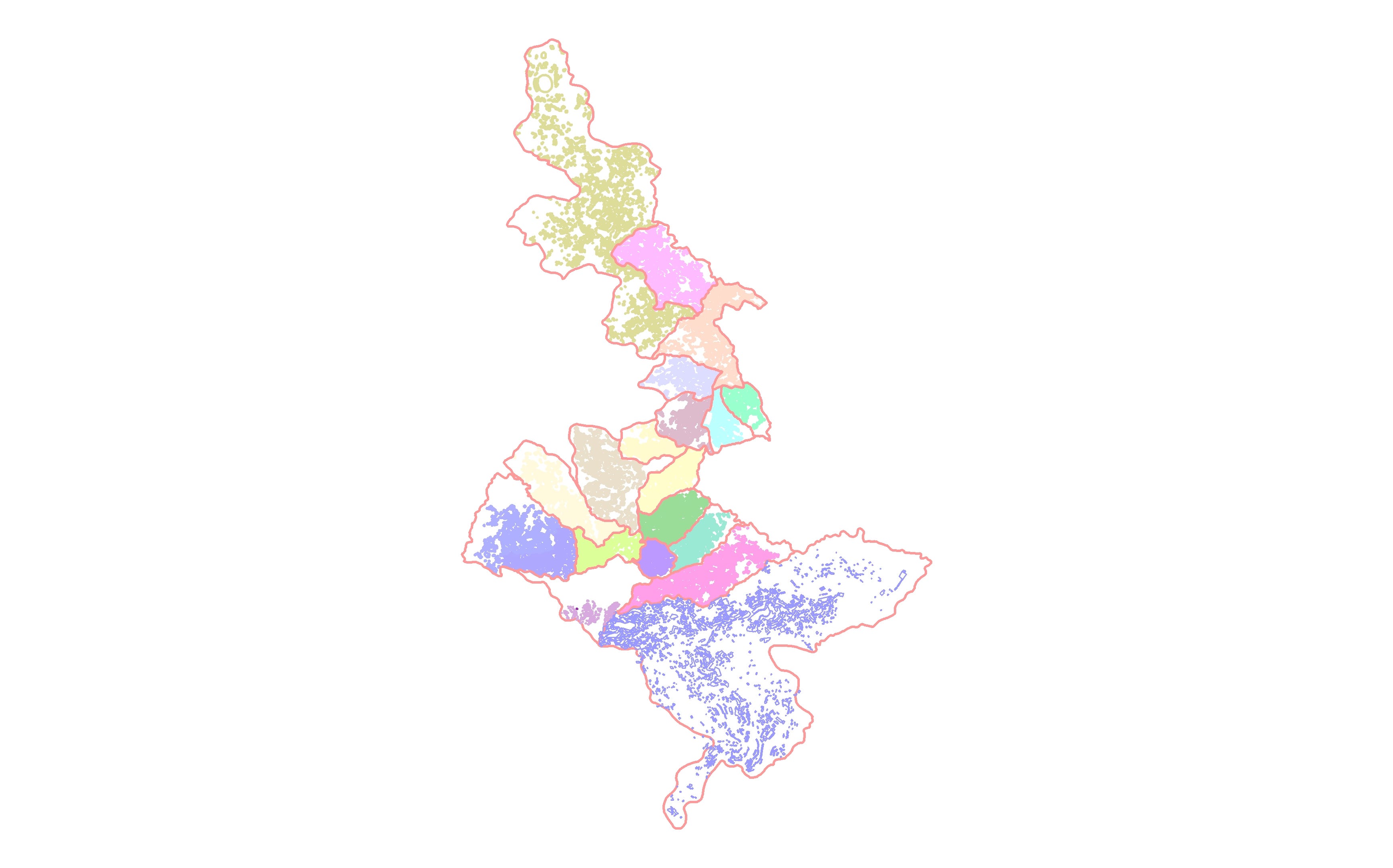

Digitization of 1000 Building Footprints in ArcGIS

Digitization of 1000 Building Footprints in ArcGIS
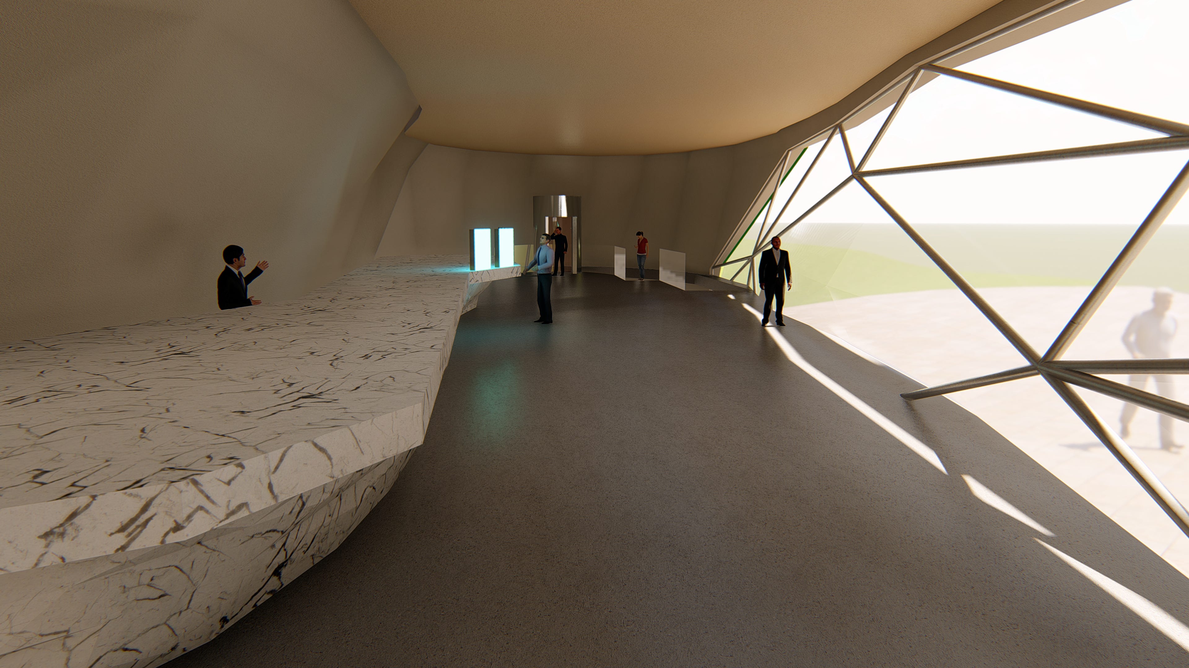

Architectural Interior and Exterior Realistic Rendering

Architectural Interior and Exterior Realistic Rendering
VR Panoramic 360 Architectural walkthrough
VR Panoramic 360 Architectural walkthrough
VR Panoramic 360 Architectural walkthrough
VR Panoramic 360 Architectural walkthrough
VR Panoramic 360 Architectural walkthrough
Infrastructural Bridge Modelling in Infra-works 360 BIM
Infrastructural Bridge Modelling in Infra-works 360 BIM
Freehand Sketch to CAD Drawing
Parametric Dynamo Revit Modelling of Complex Skyscrapers
Parametric Dynamo Revit Modelling of Complex Skyscrapers
Parametric Dynamo Revit Modelling of Complex Skyscrapers
Digitization of 1000 Building Footprints in ArcGIS
Digitization of 1000 Building Footprints in ArcGIS
Architectural Interior and Exterior Realistic Rendering
Architectural Interior and Exterior Realistic Rendering
Értékelések
Változtatások elmentve
1 - 2 / 2 értékelés látható
$49,92 USD
Matlab and Mathematica
Cartography & Maps
Geolocation
Mathematics
Geospatial
M

•
$365,00 USD
3D Rendering
AutoCAD
3D Modelling
E

•
Tapasztalat
Senior Land Surveyor (Building Information Modelling)
jan. 2018 - jan. 2020 (2 év)
1. Preparing Web-Based Online Interactive GIS Maps in Global Mapper and ArcGIS.
2.Coordinates Datum Transformation and Assigning Projected Coordinate System to GIS maps and IFC Drawings.
3.4D 5D Construction Operations Simulations in Bexel Manager.
5.Structural Design Clash Detections Between Existing Details and Proposed Structures in Revit Structural
6.AR/VR Panoramic Rendering of 3D Models for Projects Proposals to ensure Deliverables.
Senior Geomatics Surveyor(Geographical Information System)
jan. 2017 - jan. 2018 (1 év)
1.Preparing Road Setting Out Plans (Alignments, Horizontal/Vertical Curves)
2.Excavation Cut/Fill & Earthwork Design Material Quantity Take-off Reports
3.Process Field Survey Data and Prepare As-Built Drawings
4.Consult Technical Support for Equipment’s Calibration.
5.Digital terrain modeling(DTM/DEM) in Surfer and Creating Contour TINNetwork Surfaces.
6.LidarPoint Cloud Data Data Processing and Georeferencing Raster Satellite Imagery in Autodesk Recap
Georeferencing for Stockpiles
Site Surveyor (Structural &Architectural)
nov. 2014 - nov. 2017 (3 év)
1.Establishing Control Station Network(Traversing).
2.Coordinate Transformation and Assigning Projected Grid Coordinate System to Shop Drawings.
3.Precise (FFL, SSL & MEP Level) Interpolations, Boundary Demarcation of Property Lines
and Parcels, Document
Controlling (Aconex),
Tanulmányok
NCert Land Surveying & Mapping
(2 év)
Végzettségek
CRICS - Chartered Surveyor
Royal Institute of Chartered Surveyors
2018
CRICS- Royal Institute of Chartered Surveyor - Pathway
PTW -Acceptor / Originator -JO
ADNOC onshore Pipeline Division
2018
Licensed By Abu Dhabi National Oil Company
Associate Surveyor -AS1
Survey of Pakistan
2017
Licensed Professional Associate Land Surveyor
Publikációk
Does Our Coordinate System Really Exists
Hilal Magazine
Article on Lambert Conic Conformal Map Projection for Kalianpur Zone
Keresse Raja K. felhasználót a munkájával kapcsolatban
Jelentkezzen be, hogy chaten keresztül megbeszélhessék a részleteket.
Hitelesítések
Képesítések
Kiemelt készségek
Hasonló szabadúszók keresése
Hasonló bemutatók böngészése
Meghívó sikeresen elküldve!
Köszönjük! E-mailben elküldtük a linket, melyen átveheti ajándék egyenlegét.
E-mailje elküldése során valami hiba történt. Kérjük, próbálja újra.
A vágólapra másolás sikertelen volt. Kérjük, jogosultságai módosítását követően próbálja meg újra.
Vágólapra másolva.
Előnézet betöltése
Hozzáférést adott a helymeghatározáshoz.
Belépési munkamenete lejárt, és kijelentkeztettük. Kérjük, lépjen be újra.