

Mostantól követi felhasználót
A felhasználó követése sikertelen.
Ez a felhasználó nem engedélyezte mások számára, hogy kövessék.
Ön már követi ezt a felhasználót.
Tagsági előfizetésével csak 0 követésre van lehetősége. Itt fejlesztheti tagságát.
Nem követi a továbbiakban felhasználót
A felhasználó követésének kikapcsolása során hiba lépett fel.
Sikeresen ajánlotta felhasználót
A felhasználó ajánlása során hiba lépett fel.
Valami hiba történt. Kérjük, frissítse az oldalt és próbálja újra.
E-mail cím hitelesítése sikeres.

islamabad,
pakistan
Itt jelenleg ennyi az idő: 2:20 du.
Ekkor csatlakozott: szeptember 22, 2020
0
ajánlás
Hassan Maqsood A.
@Hassanmaqsood1
0,0
0,0
0%
0%
islamabad,
pakistan
N/A
Teljesített megbízások
N/A
Költségvetésen belül
N/A
Határidőn belül
N/A
Ismételt megbízási arány
GIS Specialist
Keresse Hassan Maqsood A. felhasználót a munkájával kapcsolatban
Jelentkezzen be, hogy chaten keresztül megbeszélhessék a részleteket.
Portfólió
Portfólió

Coverage Analysis


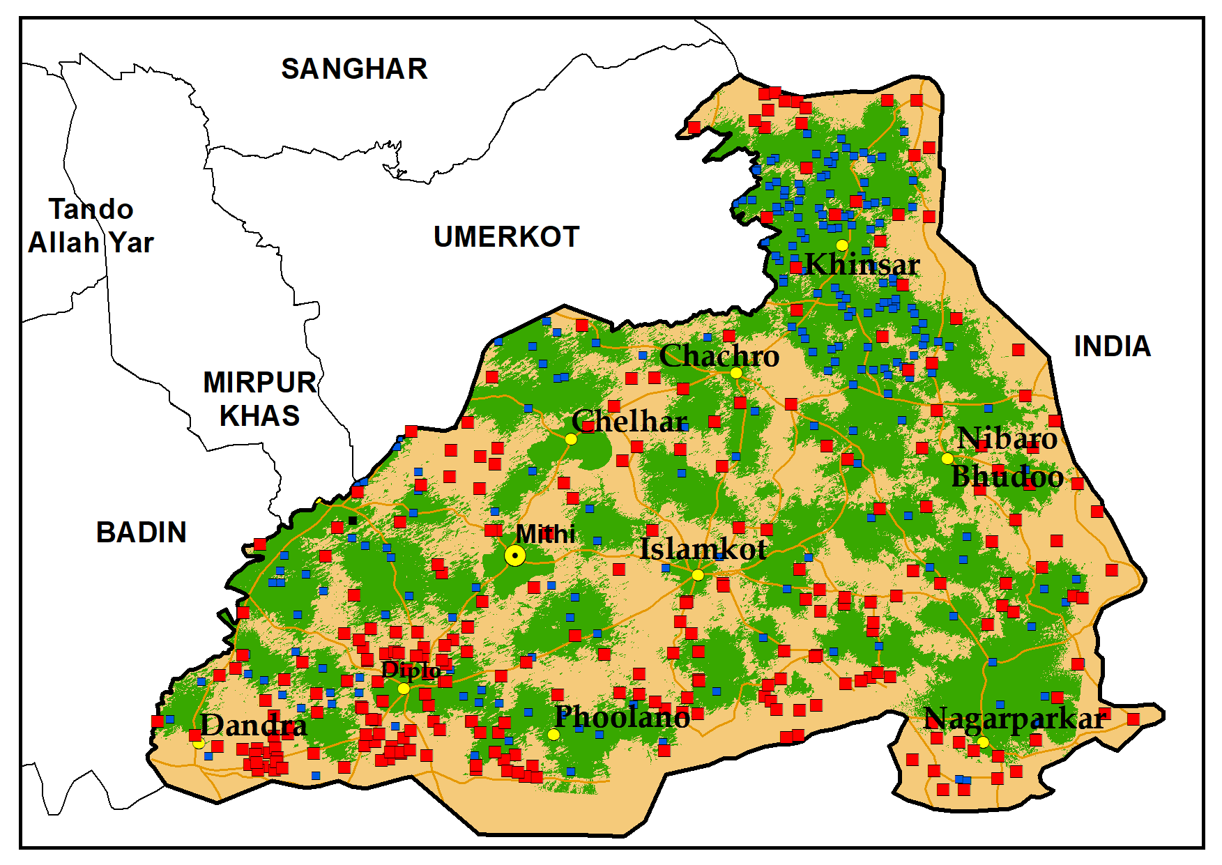
National Park (LULC)
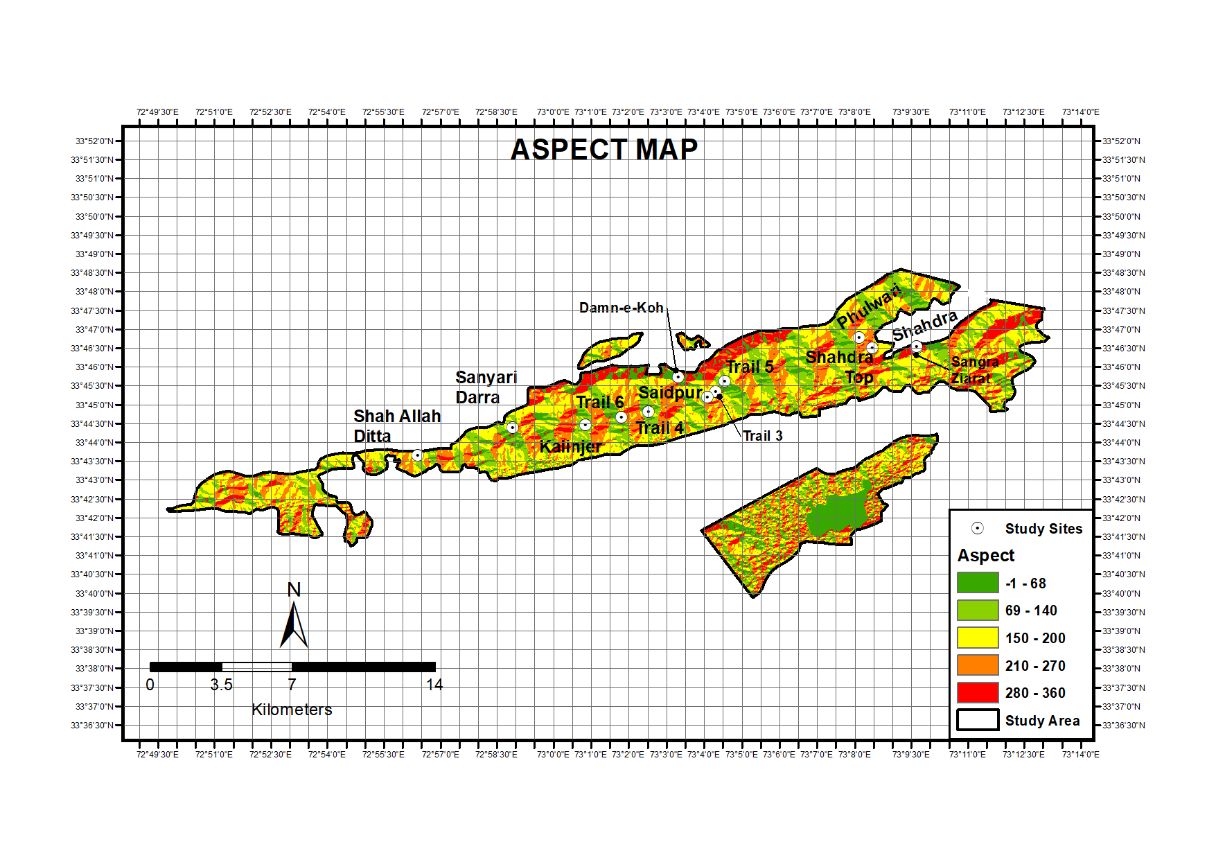

Slope and Aspect

Slope and Aspect


National Park and Species Locations


Real Estate Transformation

Real Estate Transformation

Real Estate Transformation


OFC Mapping

OFC Mapping
Coverage Analysis
National Park (LULC)
Slope and Aspect
Slope and Aspect
National Park and Species Locations
Real Estate Transformation
Real Estate Transformation
Real Estate Transformation
OFC Mapping
OFC Mapping
Értékelések
Változtatások elmentve
Nincsenek megtekinthető értékelések!
Tapasztalat
GIS Specialist
okt. 2020 - Jelenleg
Pakistan's Telecom infrastructure planning
Research Assistant GIS
jan. 2020 - szept. 2020 (8 hónap, 1 nap)
Real estate transformation
Tanulmányok
GIS/Remote Sensing
(4 év)
Keresse Hassan Maqsood A. felhasználót a munkájával kapcsolatban
Jelentkezzen be, hogy chaten keresztül megbeszélhessék a részleteket.
Hitelesítések
Kiemelt készségek
Hasonló szabadúszók keresése
Hasonló bemutatók böngészése
Meghívó sikeresen elküldve!
Köszönjük! E-mailben elküldtük a linket, melyen átveheti ajándék egyenlegét.
E-mailje elküldése során valami hiba történt. Kérjük, próbálja újra.
A vágólapra másolás sikertelen volt. Kérjük, jogosultságai módosítását követően próbálja meg újra.
Vágólapra másolva.
Előnézet betöltése
Hozzáférést adott a helymeghatározáshoz.
Belépési munkamenete lejárt, és kijelentkeztettük. Kérjük, lépjen be újra.